TEST HEAD CASE: Difference between revisions
No edit summary (change visibility) |
|||
| (27 intermediate revisions by 2 users not shown) | |||
| Line 1: | Line 1: | ||
<div class="title">Sediment Test Headland Case</div> | <div class="title">Sediment Test Headland Case</div> | ||
This test case checks the ability of a model to represent 1) simplified alongshore transport, 2) implementation of open boundary conditions, and 3) resuspension, transport, and deposition of suspended-sediment. This case is based on Signell and Geyer (1991) | This test case checks the ability of a model to represent 1) simplified alongshore transport, 2) implementation of open boundary conditions, and 3) resuspension, transport, and deposition of suspended-sediment. This case is based on [[Bibliography#SignellRP_1992a|Signell and Geyer (1991)]]. | ||
[[Image:Test_case_4.gif|center]] | [[Image:Test_case_4.gif|center]] | ||
| Line 10: | Line 10: | ||
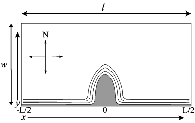
The model domain is open at the east and west ends, has a straight wall at the north end, and a parabolic headland along the south wall. | The model domain is open at the east and west ends, has a straight wall at the north end, and a parabolic headland along the south wall. | ||
{| border="1" | :{| border="1" | ||
!Model Parameter | !Model Parameter | ||
!Variable | !Variable | ||
| Line 16: | Line 16: | ||
|- | |- | ||
|Length (east-west) | |Length (east-west) | ||
|< | |align="center"|<span class="blue">l</span> | ||
|100000 m | |100000 m | ||
|- | |- | ||
|Width (north-south) | |Width (north-south) | ||
|< | |align="center"|<span class="blue">w</span> | ||
|50000 m | |50000 m | ||
|- | |- | ||
|Depth | |Depth | ||
|< | |align="center"|<span class="blue">h</span> | ||
|20 m | |20 m | ||
|} | |} | ||
| Line 32: | Line 32: | ||
Single grain size on bottom: <br> | Single grain size on bottom: <br> | ||
{| border = "1" | :{| border="1" | ||
!Model Parameter | |||
!Variable | |||
!Value | |||
|- | |||
|Size | |Size | ||
|< | |align="center"|<span class="blue">D<sub>50</sub></span> | ||
|0.1 mm | |0.1 mm | ||
|- | |- | ||
|Density | |Density | ||
|< | |align="center"|<span class="blue">ρ<sub>s</sub></span> | ||
| | |2650 kg/m<sup>3</sup> | ||
|- | |- | ||
|Settling Velocity | |Settling Velocity | ||
|< | |align="center"|<span class="blue">w<sub>s</sub></span> | ||
|0. | |0.50 mm/s | ||
|- | |- | ||
|Critical | |Critical shear stress | ||
|< | |align="center"|<span class="blue">τ<sub>c</sub></span> | ||
| | |0.05 N/m<sup>2</sup> | ||
|- | |- | ||
|Bed | |Bed thickness | ||
|< | |align="center"|<span class="blue">bed_thick</span> | ||
|0.005 m | |0.005 m | ||
|- | |- | ||
|Erosion Rate | |Erosion Rate | ||
|< | |align="center"|<span class="blue">E<sub>0</sub></span> | ||
| | | 5e-5 kg/m<sup>2</sup>/s | ||
|} | |} | ||
==Forcing== | ==Forcing== | ||
Coriolis f = 1.0 e-4 <br> | Coriolis <math>\color{blue}{f}\color{black}{~ =~ 1.0~ e^{-4}}</math><br> | ||
No heating/cooling <br> | No heating/cooling <br> | ||
No wind | No wind | ||
==Initial Conditions== | ==Initial Conditions== | ||
<math>u \ | <math>\color{blue}{u}\color{black}{~ =~ 0~ m^{3}}</math><br> | ||
Salinity = 0 <br> | <math>Salinity~ =~ 0</math><br> | ||
<math>\color{blue}{Temperature}\color{black}{~ =~ 20^{\circ}C}</math> | |||
Bathymetry: | Bathymetry: | ||
Depths increase linearly (slope = 0.0067) from a minimum depth of 2 m at all alongshore points from the southern land boundary offshore to a maximum depth of 20 m at a point 3 km offshore. Offshore of 3 km there is a constant depth of 20 m.<br> | :Depths increase linearly (slope = 0.0067) from a minimum depth of 2 m at all alongshore points from the southern land boundary offshore to a maximum depth of 20 m at a point 3 km offshore. Offshore of 3 km there is a constant depth of 20 m.<br> | ||
==Boundary Conditions== | ==Boundary Conditions== | ||
| Line 77: | Line 81: | ||
North, south = walls with no fluxes, no friction<br> | North, south = walls with no fluxes, no friction<br> | ||
South wall = parabolic headland shape<br> | South wall = parabolic headland shape<br> | ||
Bottom roughness <math>Z_{ | Bottom roughness <math>\color{blue}{Z_{\circ}}\color{black}{~ =~ 0.015~ m}</math><br> | ||
Flow and elevation at western boundary is imposed.<br> | Flow and elevation at western boundary is imposed.<br> | ||
Flow on eastern boundary is open radiation condition, or water level based, or Kelvin wave solution.< | Flow on eastern boundary is open radiation condition, or water level based, or Kelvin wave solution. | ||
Flow and elevation, eastern/western boundaries: | |||
:Reference velocity <math>\color{blue}{u_{\circ}}\color{black}{~ =~ 0.5~ m/s}</math> | |||
:Celerity <math>\color{blue}{C}\color{black}{~=~} \sqrt{\color{blue}{g}\color{black}{\times 20.0}}</math> | |||
:Reference water level <math>\color{blue}{\xi_{\circ}}\color{black}{~ =~}\color{blue}{u_{\circ}}\color{black}{}/\sqrt{(\color{blue}{g}\color{black}{/20)}}</math> | |||
:Wave period <math>\color{blue}{T}\color{black}{~ =~ 12}</math> hours (43200 seconds) | |||
:Wave length <math>\color{blue}{L}\color{black}{~ = }\color{blue}{C}\color{black}{\times }\color{blue}{T}</math> | |||
:Wave number <math>\color{blue}{k}\color{black}{~ =~ (2\times\pi)/}\color{blue}{L}</math> | |||
For each point <math>y</math> along the boundary at time <math>\color{blue}{t}</math>: | |||
Water level <math>\color{blue}{\xi}\color{black}{}~ =~\color{blue}{\xi_{\circ}}\color{black}{}\times exp(\color{blue}{-f}\color{black}{}\times y/\color{blue}{C}\color{black}{}) \times cos(\color{blue}{k}\color{black}{} \times (x - \color{blue}{C} \color{black}{} \times \color{blue}{t}\color{black}{}))</math> | |||
{{note}}'''Note:''' <math>x</math> at western boundary is <math>\color{blue}{-L}\color{black}{}/2</math> | |||
Depth-mean flow <math>\color{blue}{<u>}\color{black}{}~ =~ \sqrt{(\color{blue}{g}\color{black}{}/20)} \times \color{blue}{\xi}\color{black}{}(y)</math> | |||
Sediment flux calculated by model<br> | |||
Surface = free surface, no fluxes<br> | |||
==Output (ASCII files suitable for plotting)== | |||
After 10 days :<br> | |||
Bed thickness<br> | |||
==Physical Constants== | |||
Gravitational acceleration <math>\color{blue}{g}\color{black}{}~ =~ 9.81~ m/s^{2}</math><br> | |||
Von Karman's constant <math>\color{blue}{\kappa}\color{black}{}~=~ 0.41</math><br> | |||
Dynamic viscosity (and minimum diffusivity) <math>\color{blue}{\nu}\color{black}{}~ =~ 1e^{-6}~ m^{2}/s</math> | |||
{{note}}'''Note:''' If a model incorporates physical constants that differ from these, and/or automatically calculates some values specified here, please specify the values used.<br> | |||
==Results== | ==Results== | ||
Latest revision as of 16:10, 17 May 2016
This test case checks the ability of a model to represent 1) simplified alongshore transport, 2) implementation of open boundary conditions, and 3) resuspension, transport, and deposition of suspended-sediment. This case is based on Signell and Geyer (1991).

Domain
The model domain is open at the east and west ends, has a straight wall at the north end, and a parabolic headland along the south wall.
Model Parameter Variable Value Length (east-west) l 100000 m Width (north-south) w 50000 m Depth h 20 m
Bottom Sediment
Single grain size on bottom:
Model Parameter Variable Value Size D50 0.1 mm Density ρs 2650 kg/m3 Settling Velocity ws 0.50 mm/s Critical shear stress τc 0.05 N/m2 Bed thickness bed_thick 0.005 m Erosion Rate E0 5e-5 kg/m2/s
Forcing
Coriolis
No heating/cooling
No wind
Initial Conditions
Bathymetry:
- Depths increase linearly (slope = 0.0067) from a minimum depth of 2 m at all alongshore points from the southern land boundary offshore to a maximum depth of 20 m at a point 3 km offshore. Offshore of 3 km there is a constant depth of 20 m.
Boundary Conditions
North, south = walls with no fluxes, no friction
South wall = parabolic headland shape
Bottom roughness
Flow and elevation at western boundary is imposed.
Flow on eastern boundary is open radiation condition, or water level based, or Kelvin wave solution.
Flow and elevation, eastern/western boundaries:
- Reference velocity
- Celerity
- Reference water level
- Wave period hours (43200 seconds)
- Wave length
- Wave number
For each point along the boundary at time :
Water level
Depth-mean flow
Sediment flux calculated by model
Surface = free surface, no fluxes
Output (ASCII files suitable for plotting)
After 10 days :
Bed thickness
Physical Constants
Gravitational acceleration
Von Karman's constant
Dynamic viscosity (and minimum diffusivity)
![]() Note: If a model incorporates physical constants that differ from these, and/or automatically calculates some values specified here, please specify the values used.
Note: If a model incorporates physical constants that differ from these, and/or automatically calculates some values specified here, please specify the values used.
Results

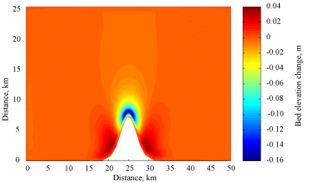
Simulations were conducted for 3.0 days. Final bed thickness is shown in Figure 1.


