TEST HEAD CASE: Difference between revisions
From WikiROMS
Jump to navigationJump to search
No edit summary (change visibility) |
No edit summary (change visibility) |
||
| Line 6: | Line 6: | ||
== | ==Domain== | ||
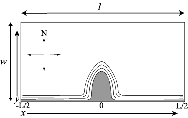
The | The model domain is open at the east and west ends, has a straight wall at the north end, and a parabolic headland along the south wall. | ||
{|border="1" | {| border="1" | ||
!Model Parameter | !Model Parameter | ||
!Variable | !Variable | ||
!Value | !Value | ||
|- | |- | ||
| | |Length (east-west) | ||
| | |<math>l</math> | ||
| | |100000 m | ||
|- | |- | ||
| | |Width (north-south) | ||
|<math>w</math> | |||
|50000 m | |||
|- | |||
|Depth | |||
|<math>h</math> | |||
|20 m | |||
|} | |||
==Bottom Sediment== | |||
Single grain size on bottom: <br> | |||
{| border = "1" | |||
|Size | |||
|<math>D_{50}</math> | |<math>D_{50}</math> | ||
|0.1 mm | |0.1 mm | ||
|- | |- | ||
| | |Density | ||
|<math> | |<math>\rho_{s}</math> | ||
|<math>2650 \,kg/m^{3}</math> | |||
|<math> | |||
|- | |- | ||
| | |Settling Velocity | ||
|<math> | |<math>w_{s}</math> | ||
| | |0.5 mm/s | ||
|- | |- | ||
| | |Critical Shear Stress | ||
|<math>\ | |<math>\tau_{c}<math> | ||
|<math> | |<math>0.05 \,N/m^{s}<math> | ||
|- | |- | ||
| | |Bed Thickness | ||
|<math> | |<math>bed\_thick</math> | ||
| | |0.005 m | ||
|- | |- | ||
|Erosion Rate | |||
|<math>E_{0}</math> | |||
|<math>5e-5 \,kg/m^{2}/s | |||
|} | |} | ||
==Forcing== | |||
Coriolis f = 1.0 e-4 <br> | |||
No heating/cooling <br> | |||
No wind <br> | |||
==Initial Conditions== | |||
<math>u \,= \,0 \,m^{3} /s</math><br> | |||
Salinity = 0 <br> | |||
Temperature = <math>20_{o}C</math><br> | |||
Bathymetry: <br> | |||
Depths increase linearly (slope = 0.0067) from a minimum depth of 2 m at all alongshore points from the southern land boundary offshore to a maximum depth of 20 m at a point 3 km offshore. Offshore of 3 km there is a constant depth of 20 m.<br> | |||
==Boundary Conditions== | |||
North, south = walls with no fluxes, no friction<br> | |||
South wall = parabolic headland shape<br> | |||
Bottom roughness <math>Z_{0} \,= \,0.015 \,m</math><br> | |||
Flow and elevation at western boundary is imposed.<br> | |||
Flow on eastern boundary is open radiation condition, or water level based, or Kelvin wave solution.<br> | |||
Flow and elevation, eastern/western boundaries: <br> | |||
==Results== | |||
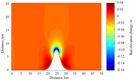
[[Image:Test_case4_fig1.gif|center|frame|'''Figure 1.''' Plan view of final bathymetric change.]] | [[Image:Test_case4_fig1.gif|center|frame|'''Figure 1.''' Plan view of final bathymetric change.]] | ||
Revision as of 17:45, 11 April 2008
Sediment Test Headland Case
This test case checks the ability of a model to represent 1) simplified alongshore transport, 2) implementation of open boundary conditions, and 3) resuspension, transport, and deposition of suspended-sediment. This case is based on Signell and Geyer (1991) Journal of Geophysical Research 96(C2): 2561-2575.

Domain
The model domain is open at the east and west ends, has a straight wall at the north end, and a parabolic headland along the south wall.
| Model Parameter | Variable | Value |
|---|---|---|
| Length (east-west) | 100000 m | |
| Width (north-south) | 50000 m | |
| Depth | 20 m |
Bottom Sediment
Single grain size on bottom:


