When I simulated the tide in Bohai and Yellow Sea, I confront a problem: the amplitude of the tide is about 30% less than the real amplitude near the coast (fig. a).
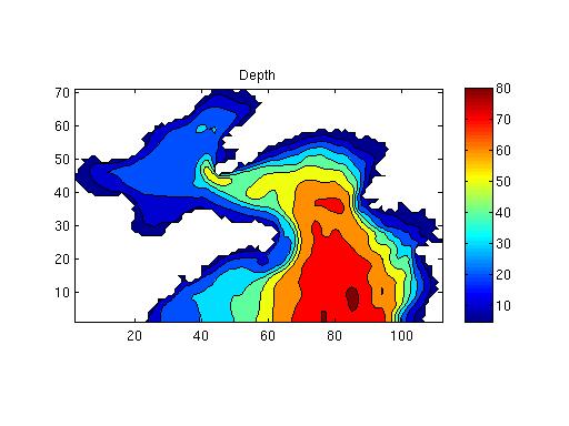
First, I thought maybe the error was caused by the topography. Therefore, I try the Etopo5 topography data. However, the amplitude result is similar with the old one, also 30% less than real. So the topo should be Ok here. Below is the topo of the domain.
Longitude: 117.5-127E Latitude:35-41N
Second, I tried to change the quadratic drag coefficient. In this domain, the drag coefficient should be 2.5x10⁻³. When I decrease the drag coefficient to 0.8x10⁻³ (fig.b), the simulated M2 tide amplitude looks proper near coast comparing with the correct M2 tide(fig.c).
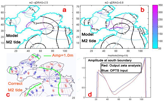
However, I think this drag coefficient is too small compare to actual 2.5x10⁻³. There must be other reasons lead to the small amplitude near coast. The tide forcing data used in my ROMS model is from OTIS (OTPS7.2, under direction of Wiki ROMS). I only have a south boundary in my domain. In figure d, I compare the M2 tide amplitude from ROMS zeta result to the input tidal forcing M2 tide amplitude. These two should be same, but they are not. And there is a obvious different around 22th and 23th points. The input tidal forcing amplitude is about 1.3m, but the ROMS output results are 0m. I checked the mask_rho, and found these two points are water points, but the ROMS output zeta are all 0m at these two points.
I am really confused.
What may be the reasons I always got small amplitude near coast?
If I use an extremely small quadratic drag coefficient 0.8x10⁻³ in this domain, can ROMS still work well when I calculate the currents and sediment transport later?
Here is my model setting:
ROMS version:461M
Resolution: 1/12 degree (about 8km) N=30 layers, dt=600, ndtfast=30, hmin=5m, Tcline=3m.
Maximum grid stiffness ratios: rx0 = 2.364813E-01 (Beckmann and Haidvogel)
rx1 = 6.975034E+00 (Haney)
Activated C-preprocessing Options:
ECSS East China Seas/ sediment transport
ANA_BSFLUX Analytical kinematic bottom salinity flux.
ANA_BTFLUX Analytical kinematic bottom temperature flux.
ANA_FSOBC Analytical free-surface boundary conditions.
ANA_M2OBC Analytical 2D momentum boundary conditions.
ANA_SMFLUX Analytical kinematic surface momentum flux.
ANA_SSFLUX Analytical kinematic surface salinity flux.
ANA_STFLUX Analytical kinematic surface temperature flux.
ASSUMED_SHAPE Using assumed-shape arrays.
AVERAGES Writing out time-averaged fields.
CURVGRID Orthogonal curvilinear grid.
DOUBLE_PRECISION Double precision arithmetic.
EAST_FSCHAPMAN Eastern edge, free-surface, Chapman condition.
EAST_M2FLATHER Eastern edge, 2D momentum, Flather condition.
EAST_M3RADIATION Eastern edge, 3D momentum, radiation condition.
EAST_TRADIATION Eastern edge, tracers, radiation condition.
MASKING Land/Sea masking.
MIX_S_TS Mixing of tracers along constant S-surfaces.
MIX_S_UV Mixing of momentum along constant S-surfaces.
MPI MPI distributed-memory configuration.
MY25_MIXING Mellor/Yamada Level-2.5 mixing closure.
NONLINEAR Nonlinear Model.
!NONLIN_EOS Linear Equation of State for seawater.
NORTH_FSCHAPMAN Northern edge, free-surface, Chapman condition.
NORTH_M2FLATHER Northern edge, 2D momentum, Flather condition.
NORTH_M3RADIATION Northern edge, 3D momentum, radiation condition.
NORTH_TRADIATION Northern edge, tracers, radiation condition.
POWER_LAW Power-law shape time-averaging barotropic filter.
PRSGRD31 Standard density Jacobian formulation (Song, 1998).
PROFILE Time profiling activated .
K_GSCHEME Third-order upstream advection of TKE fields.
RHO_SURF Include difference between rho0 and surface density.
!RST_SINGLE Double precision fields in restart NetCDF file.
SALINITY Using salinity.
SOLVE3D Solving 3D Primitive Equations.
SOUTH_FSCHAPMAN Southern edge, free-surface, Chapman condition.
SOUTH_M2FLATHER Southern edge, 2D momentum, Flather condition.
SOUTH_M3RADIATION Southern edge, 3D momentum, radiation condition.
SOUTH_TRADIATION Southern edge, tracers, radiation condition.
SSH_TIDES Add tidal elevation to SSH climatology.
TS_U3HADVECTION Third-order upstream horizontal advection of tracers.
TS_C4VADVECTION Fourth-order centered vertical advection of tracers.
TS_DIF2 Harmonic mixing of tracers.
UV_ADV Advection of momentum.
UV_COR Coriolis term.
UV_C4ADVECTION Fourth-order centered differences advection of momentum.
UV_QDRAG Quadratic bottom stress.
UV_TIDES Add tidal currents to 2D momentum climatologies.
UV_VIS2 Harmonic mixing of momentum.
VAR_RHO_2D Variable density barotropic mode.
Thanks!